The New City - Then and Now
Some 166 years after the creation of the original Dade County, residents of the Old Cutler Bay area are thinking of taking charge of some of the municipal services from Miami-Dade County by incorporating a city.
The proclamation which established the original Dade County read: "Acts of 1836, Laws of Florida, Chapter 937. Chapter 1 - Be it enacted by the Governor and Legislative Council of the territory of Florida, That the district of the country comprehended within the following limits, viz., commencing at the west end of Bahia Honda Key and running in a direct line to lake Macaco; thence on a direct line to the head of the north Prong of Potomac or Hillsborough River, and down said river to the ocean, shall constitute a county called Dade County."
The county was named in honor of Major Francis L. Dade. The new town of Miami displaced old Fort Dallas. Miami was a town with tropical heat combined with the crude "bucket" sewage system and resultant water pollution. Conditions were so bad that they prompted a soldier to write home in 1898, "If I owned both Miami and Hell, I'd sell Miami and go to live in Hell."
The sentiment in favor of separation in the northern portion of the original Dade County was strong and thus Palm Beach County was created in 1909. Broward County was created in 1913.
The agriculturally rich area of Homestead was an important component of Miami-Dade County, so were the small communities located between Miami and Homestead. Communities named Cutler, Kendall, Perrine, Peters, and Princeton.
If incorporated, the City of the Future could be eighth largest city in the county with a population of about 30,000. In 1840 the population of Dade County was 446. In 1898, when a charter was granted for the first telephone exchange in Miami, the first telephone directory contained a list of 87 subscribers. The original service had plans to extend telephone lines from New River to Cutler
It is interesting to know that a few months after the creation of Dade County in 1836, an act of Congress authorized the sale of government lands to fund the University of Florida and in addition the Territorial Treasurer was instructed to demand all monies then due from the rent of school lands. Records show that little money was collected mostly due to difficulties in transportation and indifference on the part of land owners.
This newspaper, Old Cutler Bay News is the first community newspaper and was first published in July 2002. Dade County got its first paper when Miami Metropolis, issued its first edition on May 15, 1896. The name of the paper was changed to Miami Daily News when the ownership of the paper fell in the hands of Gov. James M. Cox of Ohio. The popular Miami Herald started off as Miami Evening Record in 1903. Later the paper became the Morning News-Record and in 1910 through a reorganization the name was changed to Miami Herald.
The first road within the boundaries of the new proposed city was Old Cutler Road.. Old Cutler Road owes its name to the former town of Cutler, founded by William Fuzzard and named for Dr. William Cutler of Massachusetts. Cutler visited the area about 1880 and encouraged Fuzzard and others to settle here. In the mid-1880's, Fuzzard cut a path from his plantation to Coconut Grove, 4.5 miles to the north. This path was gradually improved and by 1902, there was a road with a crushed rock surface extending six miles south of Cutler. Today the new city will have 83.16 miles of roadway and about 170.37 miles of roadway lanes.
The total revenue of the Dade County in 1875 was $285. Based on last year's budget, it is estimated that the revenues of the new proposed city will be more than $8 million.
Area of Cutler Ridge
Basically the area covers 9.7 square miles. The boundaries are approximately as follows: on the North by SW 184 Street (Eureka Drive) from the Florida Turnpike to Biscayne Bay; on the West from SW 184 Street following US 1 to SW 112 (Allapattah Road) and then along SW 126 (Hanlin Mills Drive); on the South by SW 216 Avenue and along historic Old Cutler Road, taking a right on SW 224 Street going east to Biscayne Bay. The Eastern Border follows the coastline of Biscayne Bay from SW 184 Street to SW 224 Street.
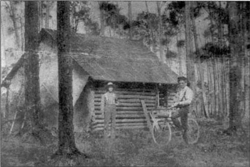
Cutler Ridge's history began in the 1870's when a Massachusetts doctor, named William C. Cutler, first visited the area and fell in love with it. Native Americans living in South Florida then referred to the area as the Big Hunting Grounds. It was officially part of the Perrine Grant awarded to Dr. Henry Perrine, in 1838. Dr. Cutler bought a 600-acre tract of this land for $1.25 per acre and wanted to establish a fruit and vegetable plantation. He built a small shack where the Ingraham Highway crossed Snapper
Creek and camped there. He tried three times to bring settlers to this area but most people id not stay. Dr. Cutler died in 1899, before he was able to establish a permanent home.
(Note: Dr. William C. Cutler was the leading practioner of medicine and surgery in Chelsea, Massachusetts. His ancestors cam from England in 1637 and were prosperous in both industry and politics. Dr. cutler was in Holliston, MA on May 17, 1837. He graduated from Laught Street Medical College in New York, in 1859 and began practice in Upton, MA in 1860. In 1866 he moved to Chelsea. He was a member of many medical societies and was a Thirty-third Degree Mason.
When small pox became an epidemic in Chelsea he began the production of the bovine vaccine virus. This was such a successful treatment that Dr. Cutler became world famous. Dr. Cutler traveled to Washington D.C. five times to deal with legal matters of the Perrine Grant. He died on May 12, 1899 at the age of 61. He did not marry or have any children).
The only one of Dr. Cutler's friends who became a permanent resident was William Fuzzard. On his first trip to the area in 1882, twenty-year-old William stayed in
Coconut Grove while he explored the area. He returned in 1883, setting up a tent before building a wooden two-story home. The only way to make money in Dade County at this time was to set up a starch mill, which Mr. Fuzzard did. Native Americans had long ago perfected the technique washing the ground up roots of the small Zamia Palm. In its natural state the plant is poisonous, but when treated properly the flour that is produced is edible. This flour was called coontie starch. The flour could also be used as laundry starch.
(Note: Although coontie mills were very profitable the Zamia plant grew very slowly and could not be cultivated. When the plant supply ran out the coontie mill industry disappeared as well. Pineapple (and later tomato) plantations became the chief means of making a living in this region).
One of Mr. Fuzzard's greatest contributions to the Cutler area was the path he cut through the wilderness. The road, which was eventually widened to a wagon trail, went from Coconut Grove to his home. This trail was the beginning of what is now called Old Cutler Road. It ran north from Fuzzard's home, went east and joined what is now Coral Reef Drive and turned into what is now Ludlam Toad and went north to Chapman Field. It still runs the length of Chapman Field (in front of the USDA Experimental Station Office) and through Fairchild Gardens. It went through Matheson Hammock up to Cocoplum Circle and along Ingraham Highway to Coconut Grove. Fuzzard's path was declared a public road in 1895. What was once traveled by Fuzzard's white mule, Samson, is the beginning of what is now the State Historic Highway of Old Cutler Road.
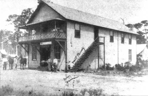
William Fuzzard met and married Miss Antonia Geiger (from a pioneer Key West Family). He built his bride a story and a half home, complete with stained glass windows and furniture from the Keys. Considering the times the home was quite impressive. Dr. Cutler spent each winter with the Fuzzards, pitching a tent in the yard. Until 1884, all mail was delivered to Coconut Grove. Mr. Fuzzard decided that there were enough people to have their own post office. He made an application and became the first postmaster. He chose the name Cutler in honor of his old friend and mentor, Dr. Cutler. The first post office was in a freight car that had been salvaged from a shipwreck.
In 1900, Henry Flagler began to build his Florida East Coast (FEC) Railway. Rather than follow the ridge from Coconut Grove to the south, the railroad was built west. Pressure to move it westward came from Commodore Monroe and other Coconut Grove pioneers who wanted to protect their waterfront estates by intrusions from the railroad and commercialism. Cutler boomed while the tracks were being laid, but the railroad was responsible for the town's ultimate demise. The Fuzzard family, along with fifty or more residents, moved north to Miami by 1905. A few people remained in the area but for the next 50 years Cutler Ridge mostly belonged to the deer, turkey, panthers, raccoons, bear, quail, snacks, gophers and ducks. Mangrove, pinewoods, palm trees, open glades, creeping vines and flowers covered the land. It was a true wilderness.
It was really not until Mr. David Blumberg began developing the land that Cutler Ridge became an organized community. In the early 1950's Blumberg and his partner, Joe Segal, convinced owner Walter Blumberg to sell him 1,400 acres of undeveloped land. Blumberg actually named this area after Dr. Cutler and the limestone ridge on which the land sits. The first housing development went up in 1954 and the Cutler Ridge Mall opened in 1960. Street names in Cutler Ridge come from holidays and the ports of call Mr. Blumberg visited as a sailor. The area around the Mall was called Seminole Plains. What is now Lakes by the Bay was labeled Lincoln City as the streets and parks were laid out. Black Point was the first post office south of Cutler, opening on February 15, 1904.
Older names of some present sites are:
Saga Bay - Tenalla Ocean Farms
Franjo Road - Earhart Road
Cutler Ridge Drive - Jackson Road
South Perrine - Peters
Quail Roost Drive - Black Creek Road
Caesar's Creek - Turtle Kraal Creek
MORE ABOUT THE STORIES BEHIND THE AREA AND ITS NAMES
In the winter of 1904-05, Wilford B. Focht arrived in Cutler and stayed at the Richmond Inn. He was a cousin of Mr. John H. Earhart, who owned 2,000 acres, which included a small farming community called Franjo, after John Earhart and his brother, Francis. Franjo Road (SW 97 Avenue) gets its name from this community.
When you drive down Old Cutler Road you will see pinelands to the west and development of fields to the east. The reason for this was that when the path from Goulds to Cutler was laid out it ran along the pine ridge to avoid flooding. This natural limestone ridge saves many areas from routine flooding.
References to Black Point and Black Creek have been traced back to a 1775 survey of the area, done by Bernard Romans, when the English owned Florida.
It is important to note that much or Cutler Ridge's history is deeply entwined with the families and peoples of the surrounding communities. Travel, commerce, schooling, socializing and church attendance brought all members of the South Dade area together in some way. These areas include Perrine, Peters, Goulds, Black Point, Larkins Modello, Princeton, and Silver Palm. The Villages of South Dade, by Jean Taylor, offers detailed stories about individual families and some of the local history that survived in family archives and oral traditions. Excellent reading.
The Perrine Grant
Henry Edward Perrine, a descendant of a French Huguenot family, was the first non-Indian resident of Cutler Ridge. He had been appointed U.S. Consul at Campeche, Yucatan sometime around 1824 where he spent ten-years. During his stay in Mexico, he became interested in establishing a colony to grow tropical crops. He began collecting and shipping seeds to acquaintances in south Florida, one of them being Charles Howe at Indian Key.
When he returned, he was offered LaFitte Island in New Orleans which he refused and instead sailed for Indian Key and then to Washington lobbying his request for a land grant in South Florida. Dr. Perrine formed The Tropical Plant Company of Florida with Judge James Webb of Key West and Charles Howe, postmaster of Indian Key. In 1838, the Legislative Council of the Territory of Florida granted land to the Tropical Plant Company of Florida.
During that same year, the Congress of the United States also granted a township of land to Dr. Henry Perrine (Perrine Grant), provided that every section in the tract has "an actual settler engaged in the propagation or cultivation of useful tropical plants" by 1846, or eight years after the passage of this act. If Perrine failed to meet this condition, the land would be forfeited to the United States.
Dr. Perrine was aware of the Indian hostilities on the mainland and as a caution he moved with his family to Indian Key in1838. Unfortunately, on August 7, 1840 the Seminole Indians attacked Indian Key resulting in Dr. Perrine's death.
After his death his widow persuaded the Congress to transfer the land rights to Perrine family for another eight-year period.
Mrs. Ann Perrine requested the aid of Charles Howe, promising him a 20 percent interest in the land if he could have it surveyed and settled in accordance with the conditions of the grant. Howe surveyed the land and brought thirty-six Bahamian families as settlers. Conflicts with the Seminole Indians, however, soon drove these new settlers off the land.
Congress was offering 160 acres of free land as an incentive to settle the area. As a result homesteaders were flocking to the south Dade area for free land, however Congress remained steadfast that the thirty-six square mile prime land tract given to the Perrine heirs was the Perrine Grant and could not to be homesteaded. By 1886, many families had taken over parts of the grant and built farms. They formed what was known as a "Squatter's Union" in order to protect their rights, hiring Dr. Cutler as their representative.
In spite of the Perrines' failure to meet the conditions of the grant, the heirs attempted to secure a patent to the land in 1862. Their efforts bore no success until 1896 when the Florida East Coast Railway (FECR), owned by Henry Flagler intervened on behalf of the Perrines, obtaining the patent.
After going through a Senate investigation, on January 28, 1897, the settlers received a total of 2,000 acres, the Perrine heirs 10,000 acres and the two railroad companies, The Florida Central and Peninsular Railroad and the Florida East Coast Railway, 5,000 acres each.
American Contract and Finance Company, a New York corporation assigned to the interest of Charles Howe and others sued everyone involved challenging that half of the Perrine land grant was theirs for their early involvement.
The FECR again assisted the Perrine heirs with the lawsuit. The Supreme Court of Florida finally decided in favor of the Perrine heirs in 1899. After securing the patent, the Perrine heirs undertook to convey an undivided one-half interest in the grant to the FECR.
Part 2: Perrine Grant Land Company
By 1896 the Land Department of FECR was incorporated as the Model Land Company (MLC), and James E. Ingraham, former president of Henry S. Sanford's South Florida Railroad Company appointed president. Although Flagler first intended the MLC to serve as his colonizing agent for Modello and other colonies in South Florida, the MLC soon became the primary land company in the Flagler System.
Flagler also created subsidiary land companies to sell lands in specific areas. The companies served as separate corporate divisions for bookkeeping purposes. A central office in St. Augustine oversaw administration of the land companies. The Perrine Grant Land Company (PGLC) organized on May 6, 1899, sold Perrine lands, which included land within the Cutler Ridge Incorporation Boundaries. The land companies assumed control of the majority of Flagler's real estate holdings, and the FECR retained property pertaining to its businesses.
Henry Flagler owned all capital stock of the FECR and the MLC. In 1902 Flagler's auditor began the transfer of titles of FECR lands to the MLC. In 1909, Flagler instructed his auditor to place all lands "for farming or for other than railway purposes" in the MLC account. In 1911, the FECR transferred Cutler Ridge lands.
The Model Land Company (MLC) Records from 1907 1967 can be found in: University of Miami, Otto G. Richter Library, Archives And Special Collections Department. The MLC Records are housed in one hundred and fifty-nine boxes and total sixty-six (66) cubic feet of files.
The files consist of the administrative and financial records of the MLC's Miami-based land agent, Frederick S. Morse, and those agencies that followed Morse, including Pepper and Potter; Pepper and Coffrin, Inc.; Frank J. Pepper and Son, Inc.; and Frank J. Pepper, Inc. The files do not represent the comprehensive records of the Model Land Company, although this material constitutes a large portion of the surviving records. Unfortunately, most of the records of the central office in St. Augustine were destroyed between 1963 and 1967.
A letter from J. E. Ingraham to Mr. Z. T. Merritt, Clerk of the Circuit Court, Miami, Fla. Regarding unpaid taxes on the land for the year 1902. tells us that Lands Situated at Township 56 South, Range 40 East, Section 03 belonged to The Perrine Grant Company. The same land today is encompassed by 184th Street on the north, 200th Street to the south, 77th Avenue to the east and SW 87th CT on the west.
Map Source Miami Dade e-Maps online
Lands Situated at Township 56 South, Range 40 East, Section 03, which is encompassed by 184th Street on the north, 200th Street to the south, 77th Avenue to the east and SW 87th CT on the west.
Similarly the MLC documents reveal that recorded in Plat Bk. 1 of the Miami-Dade County on page 11 that lands Situated at Township 56 South, Range 40 East, Section 04, which is encompassed by 184th Street on the north, 200th Street to the south, 87th Avenue to the east and Gulf stream Road on the west. Were also owned by The Perrine Grant Company
Map Source Miami Dade e-Maps online
Lands Situated at Township 56 South, Range 40 East, Section 04, which is encompassed by 184th Street on the north, 200th Street to the south, 87th Avenue to the east and Gulf stream Road on the west.
Letters, Timber Permits and other records from MODEL LAND COMPANY RECORDS. Also show us that the Northern portion of the Cutler Ridge Incorporation area was owned by The Perrine Grant Company. Look at Pictures 1 and 2
Picture 1
Map Source Miami Dade e-Maps online
Lands Situated at Township 56 South, Range 40 East, Section 05, which is encompassed by 184th Street on the north, 200th Street to the south, Gulf stream Road to the east and SW 107th Ave. on the west.
Picture 2
Map Source Miami Dade e-Maps online
Lands Situated at Township 56 South, Range 40 East, Section 06, which is encompassed by 184th Street on the north, 200th Street to the south, 107th Ave. to the east and SW 117th Ave. on the west.
Dr. W. S. Burkhart was from Cincinnati, Ohio he claimed that he had discovered the greatest blood purifier ever. 6 months treatment in one of his vegetable compounds cost one dollar.
Dr. W.S. Burkhart of Cincinnati owned hundreds of acres of lands in the Southern portion of the Cutler Ridge Incorporation area (See Pictures 3,4and 5). In the words of F. S. Morse " He has bought several hundred acres of marl prairie land in Sections 9,16 and 17 of 56-40....
F.S. Morse described Dr. W.S. Burkhart as ". a very enthusiastic and apparently well-to-do patent medicine man, who has bought considerable property in this county and whose disposition is in the way of growing vegetables and fruits."
Dr Burkhart in his letter to Morse wrote " Now Mr. Morse, I will be willing to buy 1000 Acres about Goulds, Suitable for Groves, I do not expect it all in one tract; but any part where I can get from 30 to one hundred acres in a block; I believe between my land and Goulds, there are some two hundred acres, and then west of Goulds, there is quite a body.
F. S. Morse in his letter to J. E. Ingraham writes "It seems to me he will find it difficult to pick out this land about Goulds as he claims, but that he will have to get further back or into the Perrine Grant."
In his negotiations with MLC, Dr. Burkhart offered $ 20 per acre for 1,000 acres of land. He offered to pay one third down and the balance in 2 annual installments at 6% interest.
To justify the $20 per acre offer Dr. Burkhart tells Morse " This country is filled with literature advertising land; at $10.00 per acre, they think if it is Florida land, its all the same, and it takes a great deal to convince them the difference between the East Coast, and West Coast, and Dade Co, from Palm Beach Co."
Morse in his letter to Ingraham also informed him that he (Morse) had quoted $30 per acre.
Picture 3
Map Source Miami Dade e-Maps online
Lands Situated at Township 56 South, Range 40 East, Section 09, which is encompassed by 200th Street on the north, 216th Street to the south, 87th Avenue to the east and SW 97th CT on the west.
Picture 4
Map Source Miami Dade e-Maps online
Lands Situated at Township 56 South, Range 40 East, Section 16, which is encompassed by 216th Street on the north, Sliver Palm Dr. to the south, 87th Avenue to the east and SW 97th Ave. on the west.
Picture 5
Map Source Miami Dade e-Maps online
Lands Situated at Township 56 South, Range 40 East, Section 17, which is encompassed by 216th Street on the north, Sliver Palm Dr. to the south, 97th Avenue to the east and SW 107th Ave. on the west.